Indoor navigation for barrier-free guidance at ETH
«Where is room H13.1 in the main building?» and «What is the fastest way to get from my current position to another building?» are questions that frequently arise during everyday life at ETH Zurich.
Staff, students, and visitors can all lose their way when navigating our complex campus. Craftsmen and Facility Management often have to transport heavy and bulky goods. Finding the right route can present a challenge for those involved. Orientation and everyday life are even more complicated for people with disabilities. Visible and invisible barriers are present throughout campus. Removing all of these barriers is the goal of the «Barrier-free ETH» programme. With the sub-project «Creating barrier-free guidance», IT Services has been tasked with implementing an indoor navigation system in all publicly accessible buildings at ETH Zurich.
Orientation in the buildings
Indoor navigation extends more familiar outdoor navigation systems like Google Maps or Apple Maps to indoor areas. Systems consist of indoor positioning, indoor maps and routing. Positioning within a building by means of smartphones or tablets is not yet widespread but interest in the subject is steadily growing. Displaying a blue dot that shows your current position in the building in real time requires an indoor positioning system (IPS) to be installed in the building. Bluetooth has established itself as a reliable technology for indoor positioning. With the help of Bluetooth Beacons, mobile devices can determine their position in the room via the IPS and display it as a blue dot on a map. Thanks to our existing Bluetooth Beacon infrastructure with around 6,500 beacons, additional beacons only need to be installed in certain areas. Beacons are small inconspicuous devices attached to walls and ceilings and emit Bluetooth signals. Their advantage lies in their compact size, versatility of use and long battery life. Bluetooth technology also offers significant potential for future, yet-to-be-determined location-based applications.
Barrier-free orientation
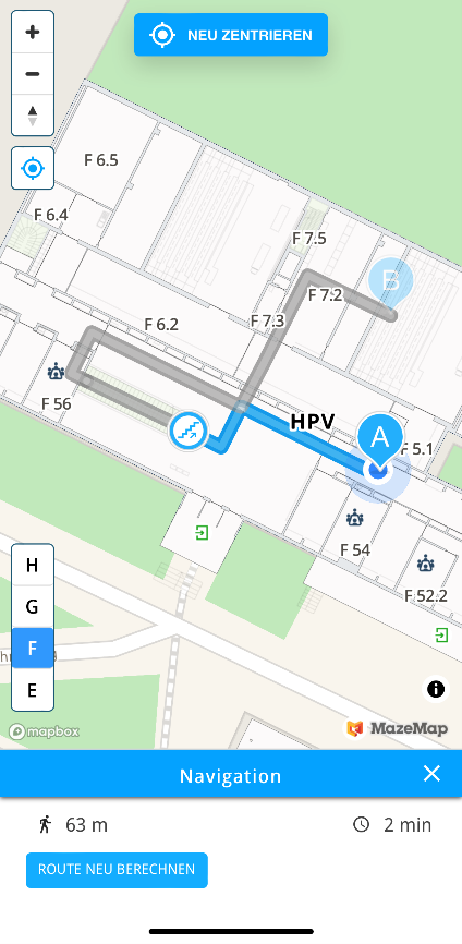
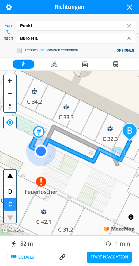
Indoor navigation follows the classic start-finish routing and includes a barrier-free routing mode, which avoids stairs and landings and calculates routes via lifts and ramps. The CAD floor plans provide an excellent data basis for calculating reliable, barrier-free routes. The start and destination points, as well as the route on the current floor, are displayed in blue. The continuation of the route on another floor is shown in grey. Stairs and lifts are represented by icons. The navigation includes a description of the route. In addition to routing for those with mobility impairments, barrier-free mode provides a service for finding routes for heavy and bulky goods. It can be used to improve daily operations at ETH.
Interactive indoor maps
Interactive indoor maps include various functionalities that fulfil numerous user requirements, including room search or displaying further information with links. All floors can be selected individually via the floor selection. Selected rooms or objects are displayed with an icon as a point of interest (POI), making it easy to find lecture halls, offices or student workplaces, as well as special safety equipment such as fire extinguishers, first aid kits and defibrillators. Users gain access to a complete overview of the building. Even without active routing, the blue dot is displayed on the map so that users can always read their own position.
Pilot Zentrum campus and Hönggerberg
The project is currently in its pilot phase. Two buildings at the Zentrum campus and two at Hönggerberg are equipped with an IPS. The first pilot phase is currently undergoing a detailed evaluation. A second pilot phase will soon begin on the same surfaces which will allow for direct comparison. The results of the pilot phase are planned for Q2. These will serve as the basis for the public tender, which is expected to take place in Q3.
The overall project will be scaled to a total area of around 400,000 square metres at various locations across 55 buildings. The rollout is planned for 2023.
- More on this topic at ETH News «Barrier-Free at ETH Zurich«
Contact
- Ricardo Roch, ITS INFRA (author of the article)
- Armin Brunner, Sub-Project Manager, ITS INFRA
- Hans-Peter Dennler, Project Manager ITS CCR

erstellt am
in News

See also the update on obstacle clearance in the ETH internal News: «Preparations for barrier-free navigation, alarm systems and evacuation procedures at ETH» https://ethz.ch/services/en/news-and-events/internal-news/archive/2022/04/preparations-for-barrier-free-navigation-alarm-systems-and-evacuation-procedures-at-eth.html
Dear Ricardo,
I read about your wonderful work related to barrier-free guidance at ETH. The first thing that jumped into my mind was my painful experience transferring goods from HIB to HCI at the Hönggerberg campus. It took me almost two hours to find my way without using stairs. In the end, I had to go completely outside the campus to the road. Although I will definitely refuse such packages in the future, I’m still curious about how to use your system to make our lives easier. I only read about your news on the website, but it seems that we don’t have access to your app/tool. Is this service available to all students? Thank you for your help.
Best regards,
Xiaohan
Dear Xiaohan
Thanks for your input. As you mentioned, to find an accessible way on the campus is sometimes very challenging. So, PolyMaps will help us to simplify the wayfinding. We’re still testing our system and will end our Beta soon. After that we want to go live and enable the public access in September with the start of the new semester. Unfortunately, you’ll have to be patient.
Best regards
Ricardo