

By Iryna Doronina

Iryna Doronina is a Visiting Professor at the Chair of Energy Systems at TU München. From 2022 to 2024, she was a Senior Researcher at ETH Zurich, where she led an in-depth study on the effects of the war on Ukraine’s energy infrastructure and explored renewable energy opportunities for recovery. Her research focuses on energy system transformation, spatial analysis, and the economic feasibility of technology transfer. Dr. Doronina specializes in developing decision-support tools and evaluating territorial potential for sustainable infrastructure and regional development.
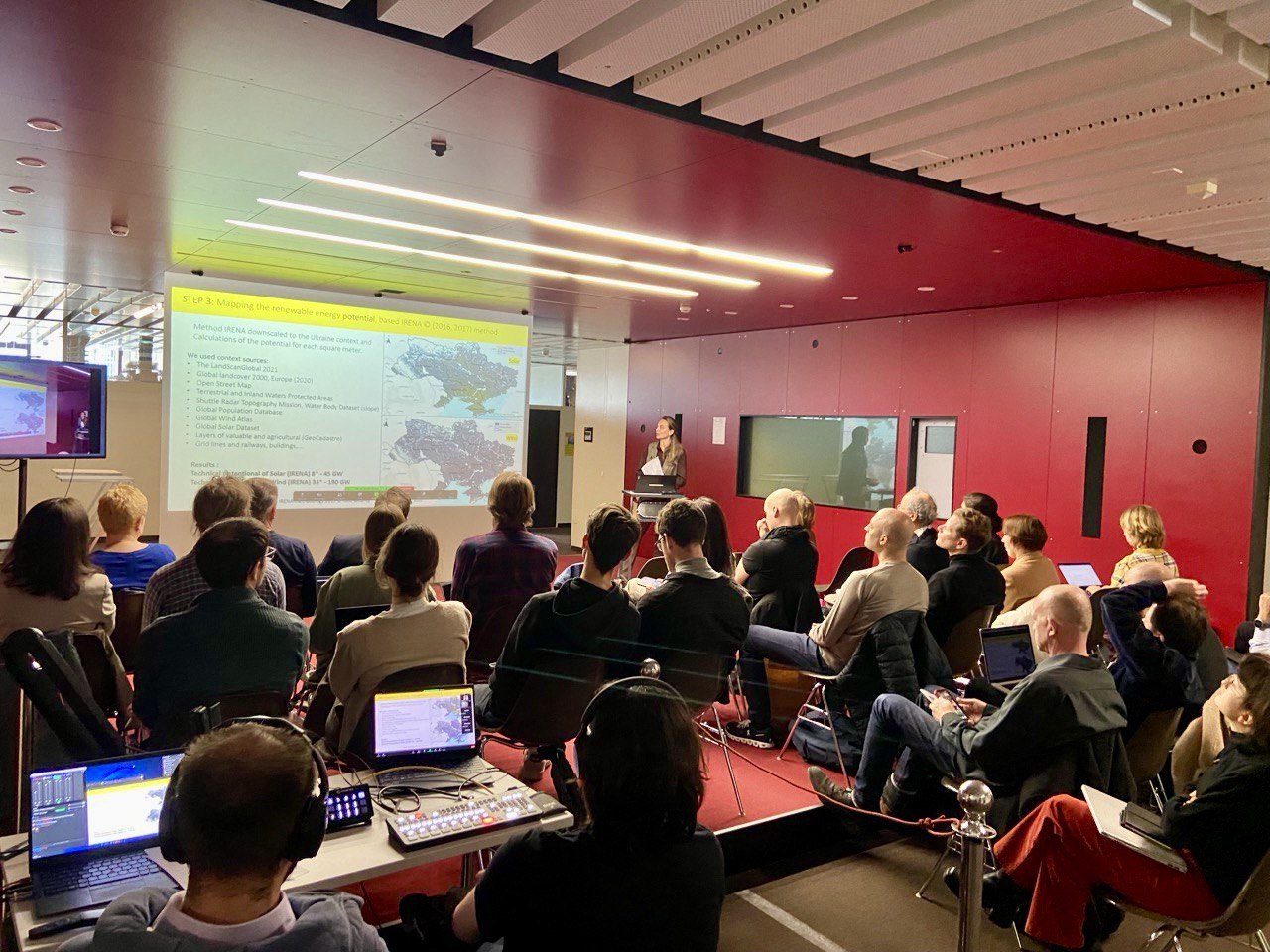
Dr. Iryna Doronina Senior Researcher at ETH in collaboration with PLUS, for the first time in Ukraine, mapped all energy infrastructure in Ukraine (more than 1700 units), identified energy sector damages and calculated detailed renewable energy potential by region, using a comprehensive spatial analysis that integrates environmental, social, and technical factors. Research identifies priority regions for solar and wind energy development, offering a strategic blueprint for the country’s post-war energy recovery.
Energy Sector Under Attack
On February 24, 2022, at exactly 00:00, Ukraine began a critical “island energy mode” test— temporarily disconnecting from the Russian and European power grids as part of requirement and plan to join to ENTSO-E (European Network of Transmission System Operators for Electricity). And after that, just three hours later, the first missiles struck. Ukraine’s energy infrastructure became a primary target.
In 2024 alone, more than 1,100 missiles and thousands of heavy drones targeted energy infrastructure across the country. Substations connecting regions were destroyed, cutting off energy flows and fragmenting the national grid. Entire regions were left with either massive surpluses or crippling shortages of electricity.
Historically, Ukraine’s energy sector was built on a foundation of high centralization and the dominance of a few major players. Local communities had no access to data on investment opportunities, and it was nearly impossible for international investors to conduct meaningful preliminary assessments without transparent information. The lack of transparency in this market hindered fair competition, increased the risk of corruption, and reinforced monopolies. Furthermore, there was a lack of comprehensive spatial studies with detailed maps assessing the structure of Ukraine’s energy system and the renewable energy potential needed to support economic decarbonization and enhance energy independence.
It became clear that Ukraine needs a tool for future recovery of Ukraine – something transparent and accessible to investors, international experts and Ukrainian communities.
Renewable Energy Potential
With the aim of supporting a transparent and science-based recovery of Ukraine’s energy sector, I decided to create a database for analysis in a Geographic Information System (GIS). Based on data from statistical and scientific sources, market reports, responses to formal requests submitted to relevant ministries and local authorities, as well as information obtained from energy market participants and professional associations, I collected and compiled my own database of 1,700 energy infrastructure facilities. This includes thermal and nuclear power plants, hydropower stations, substations, and renewable energy facilities – both those currently in operation and those that have been damaged or destroyed. Distribution and transmission networks were also included, as well as regional power systems. All facilities were manually mapped, verified, and standardized to ensure a transparent and consistent spatial database for analysis.
The next step involved conducting a spatial analysis of Ukraine’s renewable energy potential. Using 25 diverse indicators – including land use restrictions, environmental impact assessments, social acceptance, and economic viability – I developed Ukraine’s first high-resolution maps, identifying suitable areas and potential for wind and solar energy generation (Fig.1 and 2). The estimates showed that Ukraine has a total geographical technical potential of more than 229 GW, including 41.19 GW of solar and 187.98 GW of wind energy
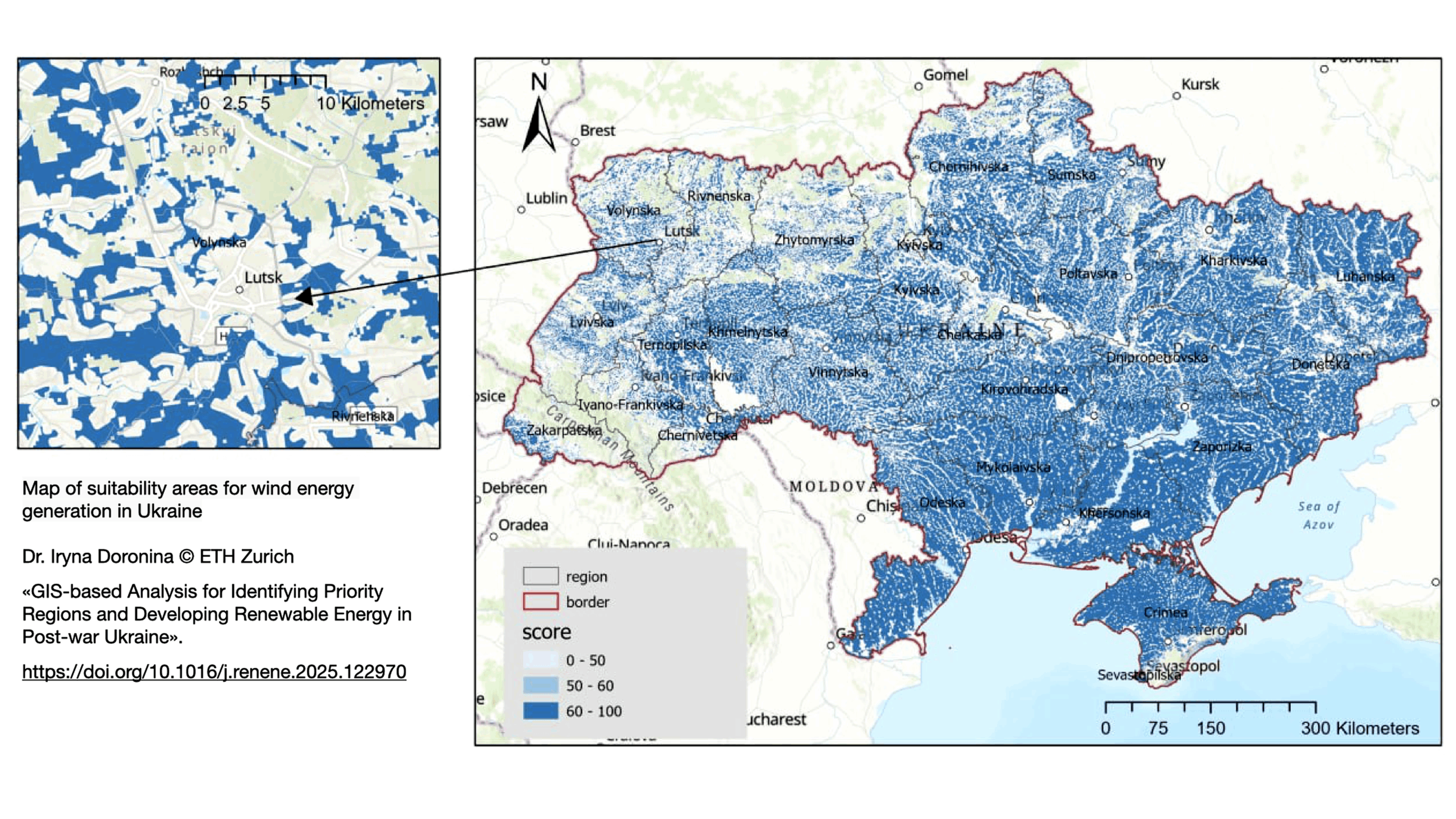
Figure 1: Wind generation potential and suitable areas map
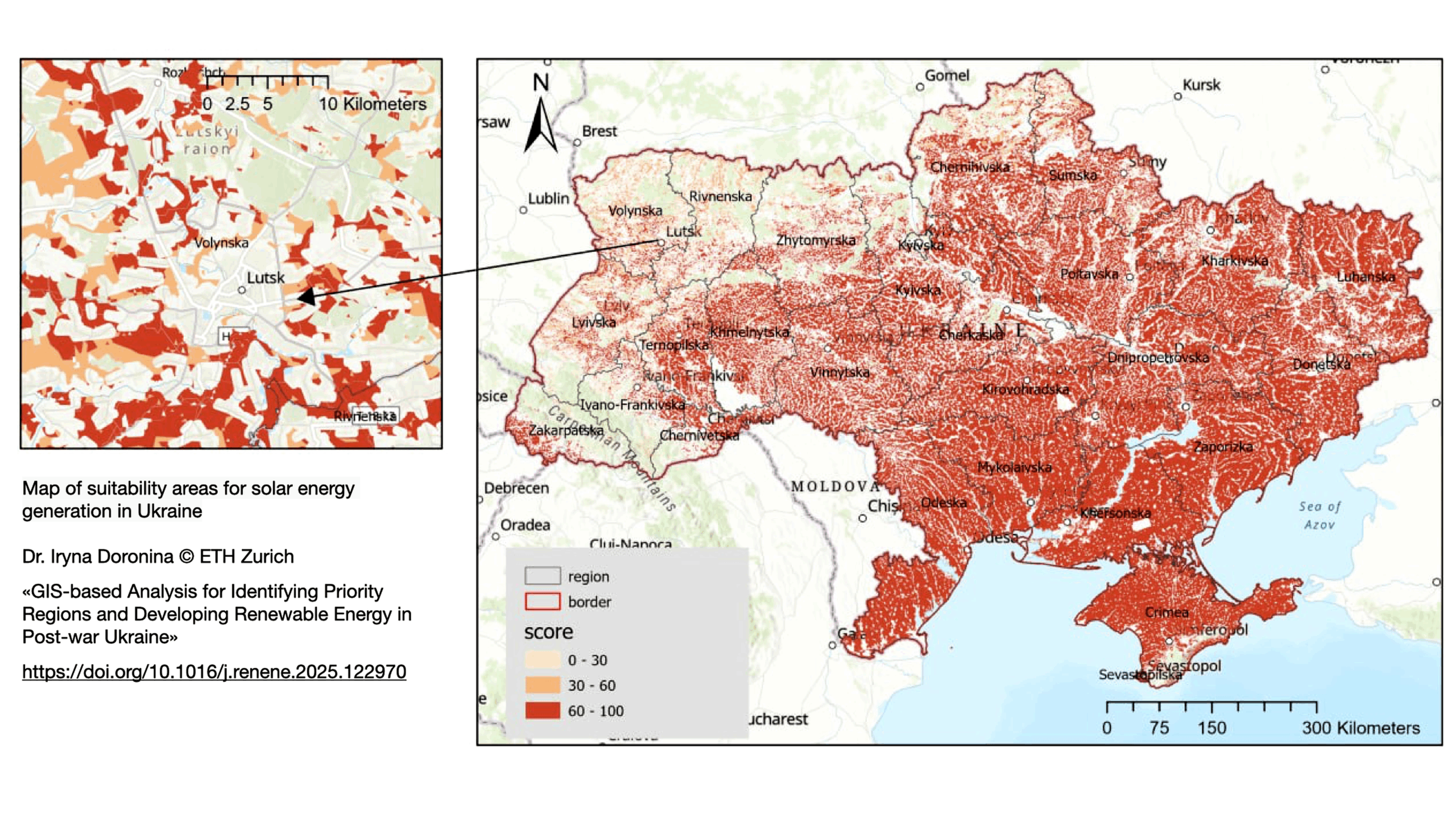
Figure 2: Solar generation potential and suitable areas map
A particularly sensitive element of this analysis is land use- Ukraine’s famous “chernozems”. The country is one of the world’s agricultural powerhouses, and preserving fertile land for food production is both a legal and ethical imperative. The analysis, therefore, incorporates not only renewable energy potential but also food security concerns and land-use tradeoffs. Identifying non-agricultural lands or low-productivity zones suitable for energy development can help avoid unnecessary conflicts between sectors.
Region Prioritization and Findings
By combining suitable solar and wind areas with a needs-based indicator — which includes infrastructure damage, political priorities, grid connection costs, public acceptance of renewable energy sources, market demand, air quality and pollution levels, and decarbonization needs — it is possible to identify priority regions for energy sector recovery and the rapid deployment of renewable energy capacity.
Analysis shows that the highest priority ratings are assigned to the southeastern regions, where most industrial production is concentrated, large deposits of minerals and critical minerals are located, and which rank first due to their high renewable energy potential and urgent need for industrial modernization and decarbonization (Figures 3 and 4).
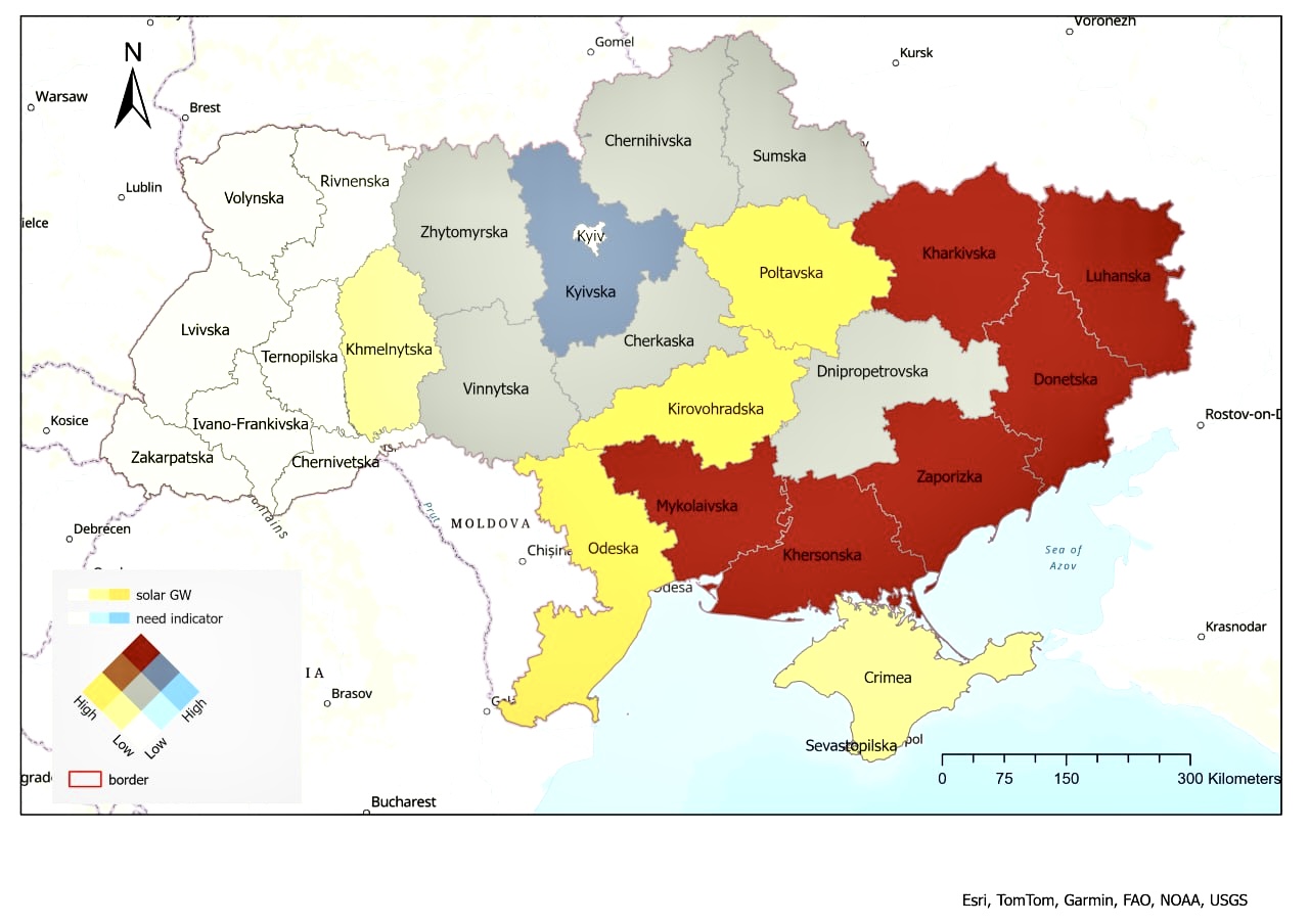
Figure 3: Priority regions for the implementation of solar energy generation
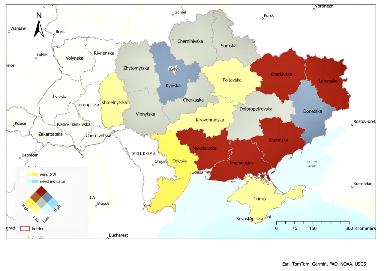
Figure 4: Priority regions for the implementation of wind energy generation
Transparency and Project Preparation Facility
As of March 2025, approximately 2,950 settlements in Ukraine have been under military operations or are occupied, hundreds of cities and energy facilities far from the front line were also attacked with missiles, that’s all posing enormous challenges for future recovery.
Rebuilding Ukraine will require vision, coordination, and unprecedented international cooperation. But it also requires data—clean, reliable, and openly available data that can guide every step from energy planning to infrastructure investment.
The detailed maps I have developed can serve as decision-support tools for local authorities, project developers, and international donors like Swiss State Secretariat for Economic Affairs, which is actively engaged in Ukraine’s recovery. For instance, identifying optimal renewable energy sites in war-damaged areas can help align reconstruction funds with decarbonization and industrial recovery goals.
Supporting the Broader Research Community
Transparency has been a core principle from the very beginning. By making findings openly accessible, the aim is to provide valuable information to researchers and local government representatives interested in energy recovery and in transforming the potential of local communities as the foundation for Ukraine’s energy resilience.
Moreover, this database opens new opportunities for international researchers to analyze development scenarios and conduct interdisciplinary studies – including modeling energy transformation and industrial decarbonization, green hydrogen production, and decentralized heating supply.
The foundation laid by these maps is to support further research, particularly the work I am currently conducting at the Technical University of Munich, where I am developing investment portfolios for Ukrainian regions with the potential to capitalize on low-carbon opportunities and decarbonize the industrial sector.
Mapping is the future for Ukraine’s recovery
The data set and GIS based methodology presented in the article have already been recognized by international agencies such as the IEA and IRENA and are being used in the development of recovery strategies, and the interest shows that research can inform real-world decision-making.
The broader ambition of this work is to foster a more transparent transformation of energy market and expansion of energy infrastructure.
By identifying high-potential areas with clear technical, social, and economic justifications, we reduce uncertainty, speed up project preparation, and help local communities take ownership of their energy futures and recovery.
Suggested citation: Iryna Doronina. “Mapping the Future Recovery of Ukraine: Regions Prioritization and Renewable Energy Potential”, Energy Blog @ ETH Zurich, ETH Zurich, May 19th, 2025, https://blogs.ethz.ch/energy/recovery-of-ukraine/
Cover image: A Ukranian flag flies at a wind farm completed in June 2021 near Odesa. (C) Nina Liashonok/Ukrinform/NurPhoto.
Read the full article here: Doronina I, Galleguillos-Torres M, Doronin V, Grêt-Regamey A, “GIS-based Analysis for Identifying Priority Regions and Developing Renewable Energy in Post-war Ukraine”, Renewable Energy, Volume 247, 2025.
Leave a Reply